By the #s: NM’s new military-controlled border zone is not a ‘60-foot buffer.’ It’s 400 square miles
A new military-controlled zone in southern New Mexico covers 400 square miles, contradicting earlier claims of a 60-foot buffer near the border.
A new U.S. military surveillance zone near the border spans 400 square miles — not the narrow strip some officials described.
Patrick Lohmann, Source New Mexico
This article was originally posted by Source New Mexico.
Earlier this week, the United States Attorney’s Office in New Mexico announced that 82 people have already been hit with the novel misdemeanor charges for “unauthorized entry into the New Mexico National Defense Areas,” a crime punishable by up to one year in prison.
That charge follows the United States Interior Department land transfer along New Mexico’s southern border to the U.S. Army, allowing federal troops to now detain and transfer individuals to federal law enforcement for criminal charges. Interior officials said the land transfer was intended to “safeguard sensitive natural and cultural resources,” and also crack down on illegal border crossings. They also said the transfer does not affect state or private land.
In touting the new measures, Defense Department officials have said the change simply amounts to converting the “Roosevelt Reservation,” which they describe in a news release as a 60-foot buffer zone along the borders Mexico shares with New Mexico, Arizona and California, into what is basically an extension of the U.S. Army Garrison Fort Huachaca in Cochise County, Arizona.
However, U.S. Sen. Martin Heinrich’s office contended in an email Friday to Source New Mexico that the DoD description mischaracterizes the actual size of the area.
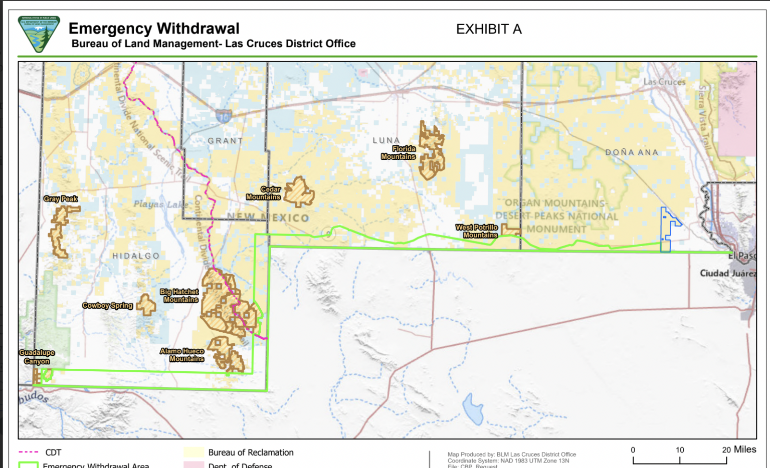
Heinrich spokesperson Caty Payette cited the Public Land Order that lists all the new parcels that are affected, along with a map showing a swath of southern New Mexico under the newly created “Emergency Withdrawal Area.”
“It’s much further than just the 60-foot Roosevelt Reservation and has huge implications for anyone unwittingly driving along Highway 9 who might pull over to stretch their legs and unwittingly trespass on a military base,” Payette said in an email.
According to a Source New Mexico analysis, the area in the “Emergency Withdrawal Area” is 406 square miles, an area more than twice the size of Albuquerque.
“We think it’s an important technicality that speaks to the seismic impact of the administration’s action,” Payette said.
See the map below
Newly created National Defense Area in New Mexico
The newly designated National Defense Area below is more than 400 square miles, excluding state and private land. It's the result of a land transfer from the Interior Department that effectively creates a military base in the area in red, empowering federal troops to detain and transfer individuals they arrest there to federal law enforcement for criminal charges.
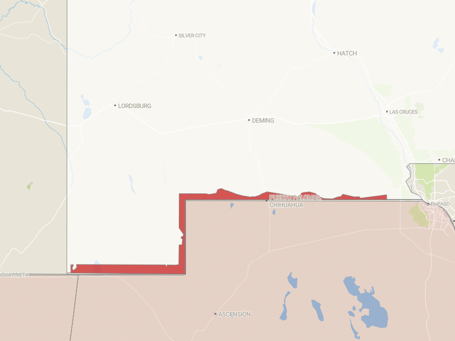
How Source created the map:
This digital rendering approximates the new militarized zone based on a publicly available map. We used Google Earth to overlay the image and trace it onto a basemap, which created a 400-square-mile polygon. Because we hand-traced the shape of the new zone, some edges may be inaccurate.
Patrick Lohmann is a reporter for Source New Mexico.
Keep reading: